How a BIM for Landscape Process was Successfully Implemented
Profiled Firm: scape Landschaftsarchitekten | Location: Düsseldorf, Germany
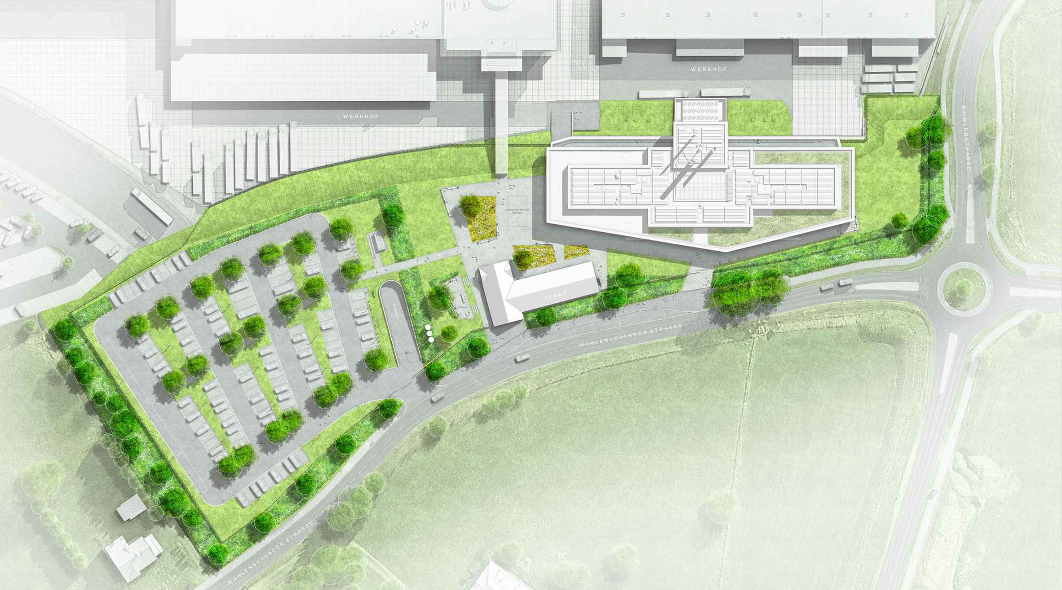
The scape Landschaftsarchitekten office was founded in Düsseldorf in 2001 by Matthias Funk, Hiltrud M. Lintel, and Rainer Sachse. The firm primarily works through a young and committed team in cooperation with urban planners, architects, ecologists, and communication designers, mainly on the planning of urban landscapes. Current projects range from master plans for entire city districts to object plans for parks, pedestrian zones, squares, and streets to detailed planning of their own street furniture systems. One of these projects was for The Viega Group, an internationally active family business in the field of mechanical and plumbing technology for sanitary and heating systems. A new seminar center is currently under construction at their headquarters in Attendorn, and Vectorworks Landmark was used to implement the landscape architecture through a BIM process.
The Viega Group Using BIM in All Areas
The seminar center’s program will not only focus on the complex system world of Viega but will also be used to inform customers about the BIM process in the field of plumbing and HVAC technology. The planning process and operation of the seminar center have become an integral part of the customer training program. This demand on the building requires a multidisciplinary planning process in accordance with BIM methodology through all service phases of the HOAI (Official Scale of Fees for Services by Architects and Engineers) for all stakeholders. In addition, the BIM model of the seminar center provides the information technology basis for subsequent facility management.
Collaboration Made Simple Thanks to a Streamlined Workflow
To prepare the integral planning process, a comprehensive BIM specification and a detailed BIM plan were developed. The initial specification defined BIM modeling using Big Closed BIM, where the same BIM software application would be used by all collaborators and is not the most ideal working environment. However, from the start of the process it became apparent that both the civil engineering and landscape architecture teams could not work optimally with these specifications, so BIM modeling was further developed to a Big Open BIM environment using Vectorworks. This decision allowed for a more collaborative, transparent, and open workflow that allowed teams to participate in all steps of the BIM process regardless of the software program they preferred to use.
Once the modeling standards were agreed upon by all collaborators, they were then implemented in Vectorworks to guarantee a complete integration of the BIM landscape model via the IFC export into the BIM coordination model. The BIM coordination model and the BIM central database were then managed in BIM collaboration software. The scape Landschaftsarchitekten office used DESITE MD, which performs similarly to BIM collaboration programs such as Solibri, Navisworks, and BIM 360. After scape Landschaftsarchitekten overcame this initial hurdle, all further BIM processes of modeling, plan creation, attribution, scheduling etc. could be accounted for. This general workflow is the same or comparable to the rest of the project team.
Modeling Terrain Surfaces with Marionette
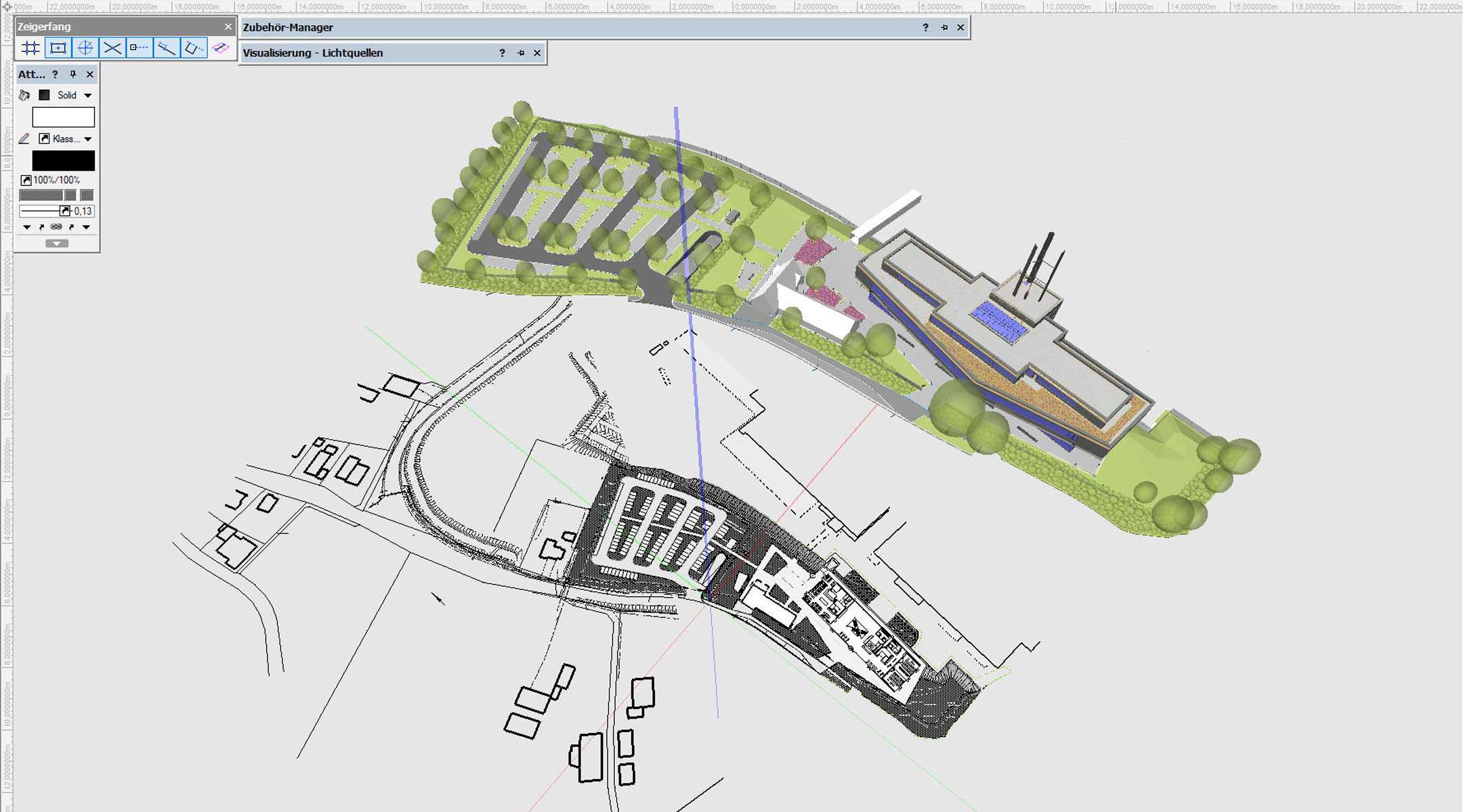
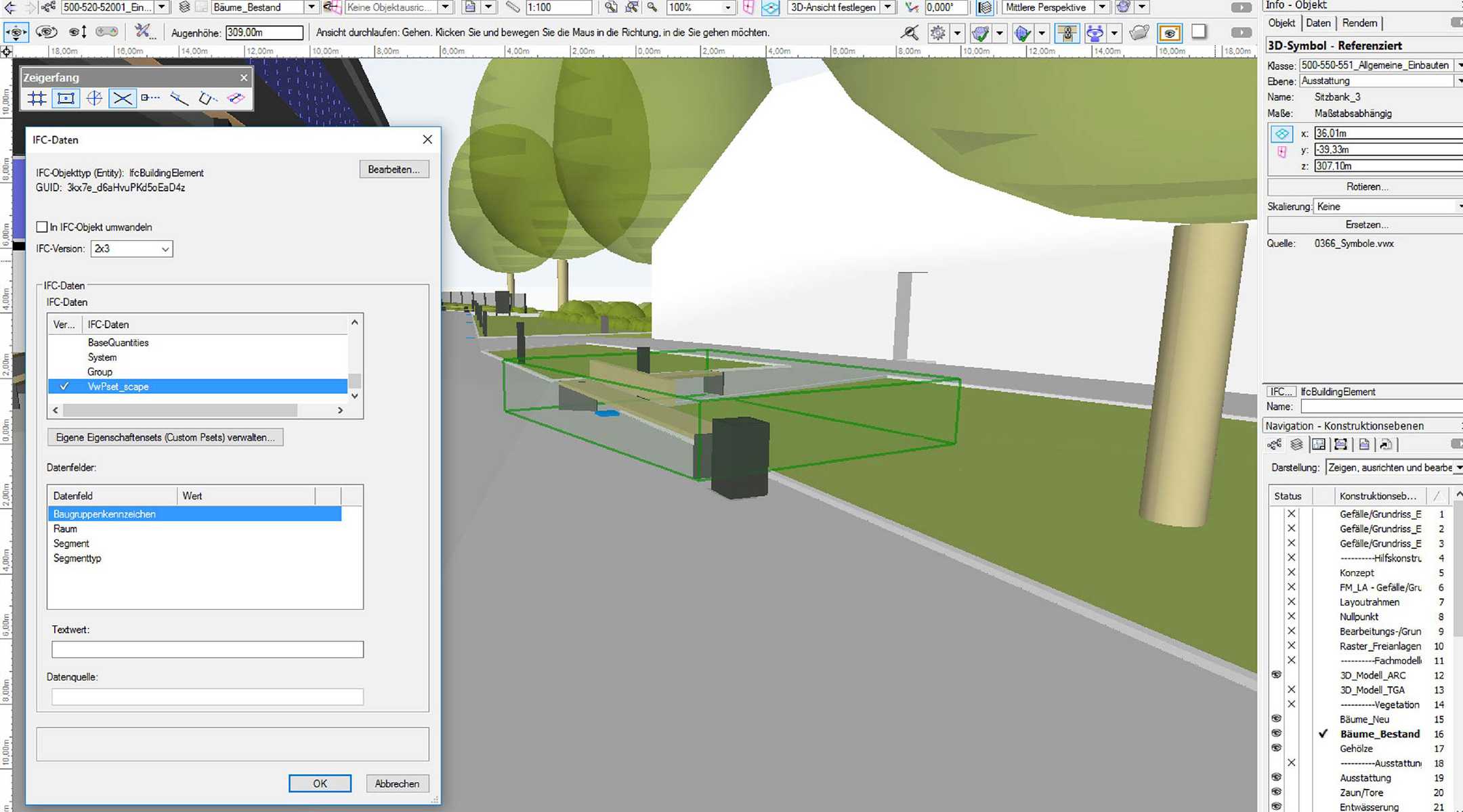
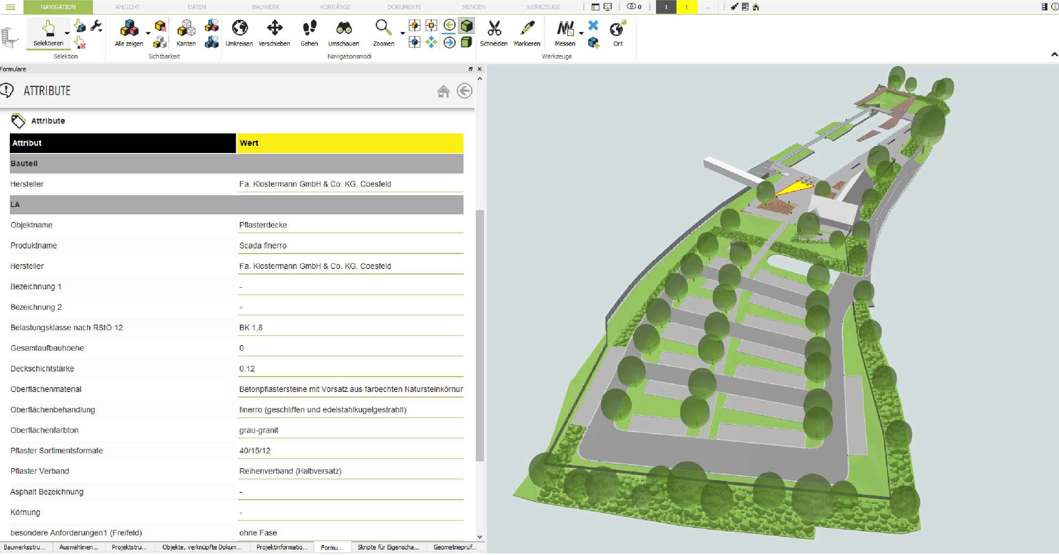
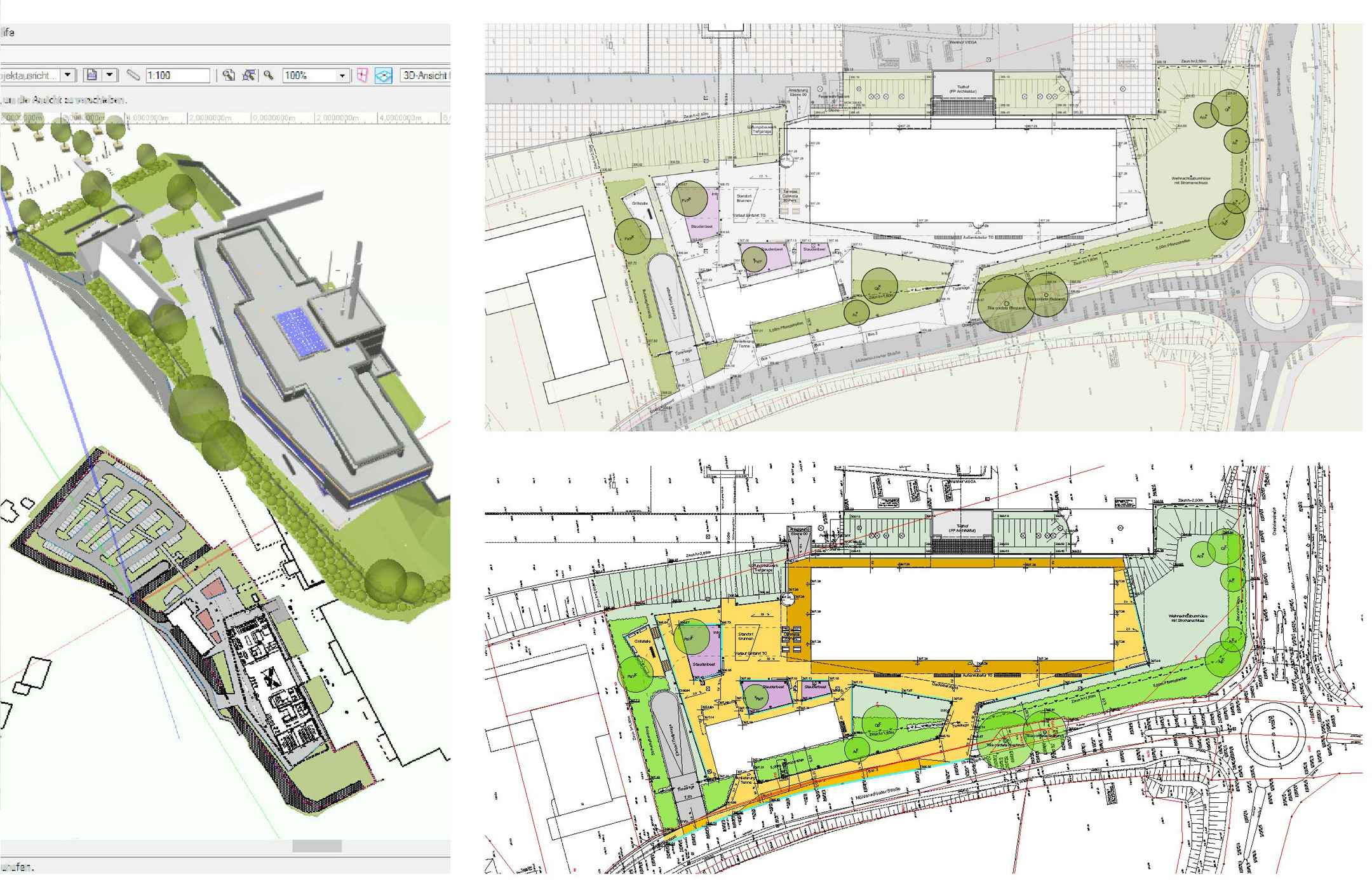
Through this process, scape Landschaftsarchitekten created their 3D BIM model in Vectorworks. For landscape architecture, there are specific intelligent objects they used such as trees, benches and lights that were very easy to integrate into their model. In the exact modeling of the terrain surfaces and path structures, scape pursued the goal of constructing exact surface inclinations with differentiated longitudinal and transverse gradients. They created their own surface and curb objects using the Grade Tool available in Vectorworks and the algorithmic modeling tool Marionette.
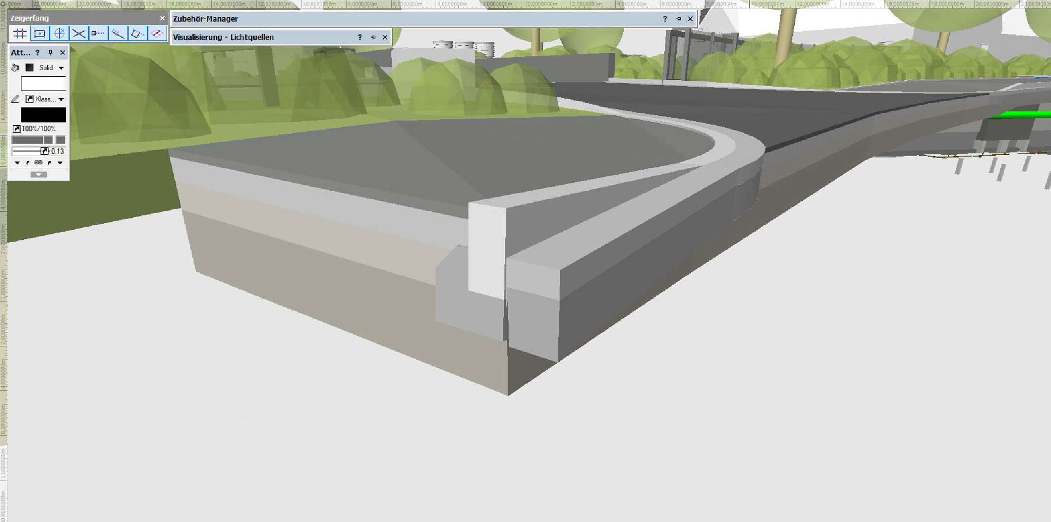
These objects, which can conform to design surface changes in height or position, enabled the modeling of a fully attributed 3D BIM terrain model of the outdoor facilities.
Since with these self-created objects the 2D representation, in line with the wall and ceiling objects of the building, was missing, scape Landschaftsarchitekten referenced the 3D landscape model in a 2D drawing of the site plan and adapted the surfaces to the 3D model.
The individual components were structured on the basis of assembly codes according to the industry-standard cost groups of DIN 276:2008. The model was then transferred to DESITE MD via the IFC file format. Within DESITE MD, Python scripts were used to generate the building structure and a factory identification system from the assembly codes in accordance with Viega's factory standards. If the attribute values were contained in the IFC import, they are transferred; any missing attributes can then be added in DESITE MD.
Plan Status: Transparent to Everyone
The discipline-specific BIM models, structured and attributed in this way, were then combined by the BIM manager into a coordination model and checked for collisions and completeness using automated test routines. All BIM models in IFC format, as well as in CPA format from DESITE MD, were available to all project members in a cloud-based BIM document management system. This enabled every team member to view the current planning status of all disciplines or, if required, to reference the respective IFC model in their BIM program.
By participating in the Viega Seminar Center project, scape Landschaftsarchitekten have emerged as pioneers of the complex processes related to BIM for landscape. The BIM coordination model is currently being prepared as the basis for the preparation of bids for interested general contractors. Until the opening of the new Viega Seminar Center, further BIM processes will be implemented and tested on real projects. This shows that a cross-discipline BIM workflow can only be implemented sensibly as Big Open BIM.
A Pioneer in BIM for Landscape Architecture
The level of detail of the BIM model is of particular importance, since it has a considerable influence on the workability of the model within different BIM software. For BIM methodology, it is not the photorealistic 3D model that is critical, but rather the data linked to the geometry. It is therefore completely sufficient if the three-dimensional BIM objects correspond in dimension and position to the real component.
This level of detail corresponds to the classic design planning according to HOAI. All further information required for the subsequent construction process can also be attached to the BIM object as two-dimensional detail drawings in DESITE MD. The same applies to documents that are generated during the construction process as an acceptance protocol or archived within the framework of facility management in the form of a maintenance protocol. The BIM object thus becomes a container that structures and archives all data over the entire life cycle of the real project.
Images courtesy of scape Landschaftsarchitekten.